


Boat NAVI

وصف لـBoat NAVI
Please try "Boat NAVI", when you do fishing by a boat.
Of course, It is convenient also when enjoying the sailboat which does not do fishing, and the cruise of a small ship.
"Boat NAVI" is an application which assists your boat fishing with Google Map and GPS data. You can save your known fishing points, and boat tracking line, with GPS data and date time. And, "Boat NAVI" navigates you to the saved point at next time. Let's teach your friend the saved point which can be fished ,using "Boat NAVI".
This application was created by 'Kei Nakazawa (uncle Kei)'.
I am a boat fishing reporter of "TURI JYOHO" which is a Japanese fishing magazine.
http://tj-web.jp/
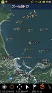
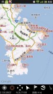
1. It is the application which used Google MAP as the base.
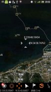
2. Tracking, such as trolling, is recordable.
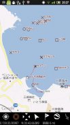
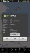
3. The point which was able to be fished can be registered.
Depth of water, sea bottom types, and a fish stock are also recordable.
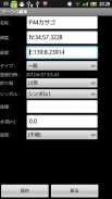
4. Other marks can also be registered.
5. The display of a direction can be performed.
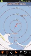
6. A concentric scale can be displayed.
7. The data registered into next time can be referred to.
version 1.7
1.You can set font size.
version 1.5
1. Improvement of imaging speed.
2. Display of boat fishing spot (only in Japan).
To edit fishing spot, wait next version. sorry.
3. Edit of Tracking Name
version 1.4
1. The form of the self-ship was used as the arrow type.
2. Improvement of display Speed.
3. A marker can be inputted into the cursor position.
4. The position of a marker can be edited.
يرجى المحاولة "قارب نافي"، عندما لم الصيد بواسطة القارب.
بطبيعة الحال، ومن المريح أيضا عندما تتمتع المراكب الشراعية التي لا تفعل الصيد والرحلات البحرية للسفينة صغيرة.
"قارب نافي" هو تطبيق الذي يساعد قارب الصيد الخاص بك مع خريطة جوجل وبيانات GPS. يمكنك حفظ الخاص بك نقطة الصيد المعروفة، وتتبع خط القارب، مع بيانات نظام تحديد المواقع والوقت الآن. و، "قارب نافي" يتنقل لك نقطة حفظ في المرة القادمة. دعونا تدريس صديقك نقطة حفظ التي يمكن صيدها، وذلك باستخدام "قارب نافي".
تم إنشاء هذا التطبيق بواسطة "كى ناكازاوا (عمه كى).
أنا مراسل من قارب الصيد "TURI JYOHO" وهي مجلة الصيد اليابانية.
http://tj-web.jp/
1. هو التطبيق الذي يستخدم خريطة جوجل كقاعدة.
2. تتبع، مثل التصيد، هو تسجيل.
3. يمكن تسجيل نقطة التي كانت قادرة على أن تكون بالصيد.
عمق المياه، وأنواع قاع البحر، ومخزون الأسماك هي أيضا للتسجيل.
4. ويمكن أيضا أن يتم تسجيل العلامات الأخرى.
5. عرض اتجاه لا يمكن أن يؤديها.
6. يمكن عرض نطاق متحدة المركز.
7. البيانات المسجلة في المرة القادمة يمكن الإشارة إليها.
الإصدار 1.7
1.you يمكن ضبط حجم الخط.
الإصدار 1.5
1. تحسين سرعة التصوير.
2. عرض بقعة قارب الصيد (فقط في اليابان).
لتحرير بقعة الصيد، انتظر النسخة المقبلة. آسف.
3. تحرير اسم من تتبع
الإصدار 1.4
1. كان يستخدم على شكل السفينة الذاتي كنوع السهم.
2. تحسين سرعة العرض.
3. يمكن إدخالها علامة في موضع المؤشر.
4. موقف علامة يمكن تحريرها.


